Storm system intensifies in Mississippi, approaches Alabama
Published 3:45 pm Thursday, April 18, 2019
|
Getting your Trinity Audio player ready...
|
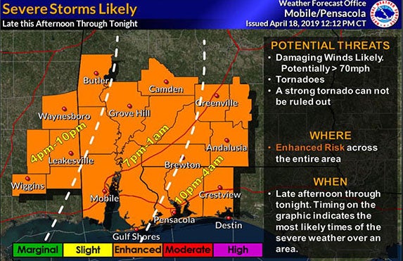
Officials in Butler County and across Alabama are watching as a storm system that is expected to hit our area tonight is intensifying as it moves from Louisiana into Mississippi.
The National Weather Service in Mobile said it expects tornado watches to begin being posted for Southeast Mississippi and Southwest Alabama by mid-afternoon. Officials expect areas such as Butler County could see watches in the late afternoon that would extend into the early morning hours. Though some storms may come through the area earlier, the ones concerning the National Weather Service are expected tonight after 7 p.m. The entire region is under an “enhanced” risk of severe thunderstorms.
The initial line of storms may diminish some, but evening redevelopment over Mississippi will bring stronger storms to our area.
“The atmosphere is most conducive in our area through the night hours,” the NWS in Mobile said.
Predictions said the storms could include damaging winds and strong tornadoes in the EF-2 to EF-3 range as well as limited flooding. Forecasters expect 1-3 inches of rain with the system. The Storm Prediction Center said there is now more probability of damaging winds with the system.
Butler County Emergency Management Director Kris Ware reminded people that they could sign up for an app that could help warn residents of weather and other situations. Visit https://member.everbridge.net/index/892807736730102# for more information.


